Why Rivers Meander Across Broad Plains
Why rivers meander across broad plains: follow erosion, sediment and abandoned bends to understand how a channel changes without assuming human intervention.
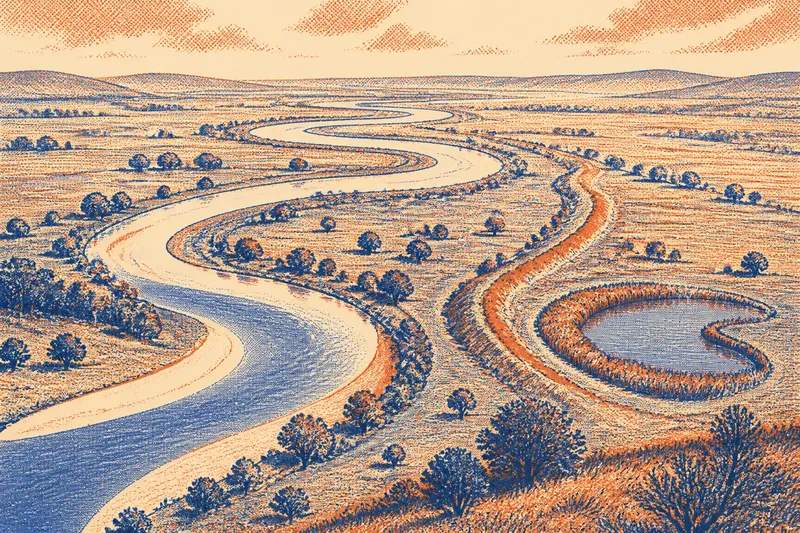
Why rivers meander across broad plains rather than taking a straight path downhill? A river crossing soft sediment can gradually shift its channel as water erodes one bank and lays material down on the other. The loops are not just marks on a map: they are stages in a process that can leave a changing pattern across the valley floor.
How bends grow
On a low-gradient plain, a river may wind through sand, silt and mud instead of cutting through resistant rock. A small deviation in the channel redirects some of the flow towards one bank. That difference can deepen the curve: faster-moving water erodes the outer bank, while slower water near the inner bank drops some of its sediment.
As the outer edge retreats and the inner edge builds out, the bend becomes more pronounced. The channel’s fastest flow shifts within the curve, so erosion and deposition continue to alter its shape. This is a local process, but repeated bends can eventually rearrange a much larger stretch of floodplain.
Rivers do not all meander in the same way. The amount of room available, the material in the banks and the volume and speed of the water all affect the pattern. A bend constrained by a valley wall, for instance, has less freedom to move sideways than one crossing a broad, open plain.
Traces beyond the channel
When a river floods, water can spread over the surrounding floodplain and leave fine sediment behind. The ground may retain subtle ridges, shallow hollows or damp strips that follow former channels. These traces are often easier to understand as a group than as isolated shapes.
A bend can become cut off if the river finds a shorter route across the narrow neck between its two arms. The old loop may remain as an oxbow lake, a crescent-shaped pond or a marshy hollow. Over time, vegetation and sediment can fill it, leaving a curved feature that resembles the active river even after open water disappears.
Other landforms offer different clues. A low ridge beside a channel may be a natural levee, built from sediment dropped when floodwater spills over the banks. Such a ridge is not the same as a deliberately raised embankment: its irregular shape and relationship to the river need to be considered alongside other evidence.
Follow one channel
Say you are reading a map of an invented place called Willow Plain. The active river loops through a wide valley; a reed-filled crescent lies beyond one bend, and a low ridge parallels a nearby reach. On a topographic map, trace the river first, then compare those features with the valley floor and any available aerial imagery.
The crescent’s curved outline could be an abandoned bend, while the ridge could be natural flood sediment. Together, they fit a river that has shifted across open ground, but neither feature identifies exactly when the change happened. Next, inspect the wider pattern: if the channel follows the plain’s natural contours and neighbouring loops show similar forms, natural meandering is a reasonable reading.
Now suppose the same map shows a straight reach cutting across several curved traces, with sharply defined banks continuing along it. That combination would make engineering a possibility worth checking against older maps or imagery. The result is not a verdict: it is a choice between interpretations, with the natural reading better supported by the first set of clues and human alteration more plausible in the second.
Clues to river bends?
Why does the outer bank wear away?
Flow is often stronger against the outside of a bend, where it can erode the bank. Slower water along the inner edge is more likely to leave some carried sediment behind.
How does an oxbow lake form?
A river may cut across the narrow neck of a bend and leave the loop disconnected from its active channel. The abandoned curve can remain as a lake or wet hollow, then gradually fill with plants and sediment.
Does a straight river reach mean it was engineered?
No. Natural conditions can produce straight reaches, and a map may simplify a channel’s shape. Look for a broader pattern, such as abrupt alignments and constructed banks, before treating engineering as the likelier explanation.
Can maps reveal when a channel shifted?
Maps from different periods may show that a river’s course changed between their publication dates, but they do not necessarily explain how or when the shift happened. Aerial imagery and visible floodplain features can add context, though the evidence may still leave the precise history uncertain.
Natural change or works
Channel straightening, bank protection, drainage and flood-control structures can alter a river’s course. A straight section beside looping reaches may invite a closer look, but shape alone does not establish human intervention. Consider whether the reach begins and ends abruptly, crosses the natural grain of the floodplain, or connects to clearly constructed banks, drains or levees.
Compare sources with care. A topographic map can show the channel and nearby contours; aerial imagery may make abandoned loops easier to spot; older maps can indicate whether a reach was once different. Each source has limits: maps simplify, vegetation hides shallow features, and a road or field boundary beside a river may follow its course rather than explain it.
For a grounded reading, work through the visible evidence:
- If the valley is broad and the river has room to curve, then natural meandering is plausible; if steep slopes confine the channel, consider the valley’s constraints before interpreting the bends.
- If a crescent-shaped wet hollow sits beside a bend, then compare its curve with the active channel; if it does not fit, do not assume it is an abandoned river loop.
- If a low ridge follows the river irregularly, then consider natural flood deposits; if a raised bank has a uniform, sharply defined line, check imagery or maps for possible construction.
- If curved traces recur across the floodplain, then read them as a possible history of channel movement; if only one ambiguous mark appears, leave its origin open.
- If a straight reach cuts across older-looking curves, then compare it with earlier maps; if the channel appears similar across sources, natural causes or cartographic simplification remain possible.
- If a straight reach joins visible drains or constructed banks, then consider human alteration; if those features are absent, avoid treating straightness alone as proof.
What not to pursue
It is not worth assigning a precise age or cause to every small kink on a map. Cartographic detail varies, vegetation can hide shallow channels, and floodwater can reshape fine features. Focus instead on the larger pattern: the river’s room to move, the relationship between bends and floodplain, and whether signs of erosion, deposition or construction recur together.
Why rivers meander across broad plains becomes clearer when each bend is read as part of a shifting channel, not as an isolated mark or automatic sign of human work. The phrase why rivers meander across broad plains points to both the physical process and the evidence it leaves behind. When a river loop seems puzzling, check what lies beside it: an old curve in the ground may reveal movement that the present channel no longer shows.