How a Village Green Fits the Settlement Around It
Read a village green through its paths, boundaries and neighbours to understand how shared ground connected homes, routes and working land.
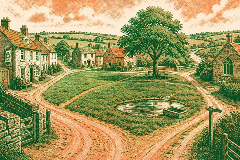
Why does a village green sit in this particular place, and what did it let people do? A village green’s position can make sense when you trace the lanes, houses and field edges around it. Rather than treating it as a decorative patch of grass, read it as part of the settlement’s layout: a space that could connect routes, separate clusters of homes or accommodate uses that did not fit neatly into a private plot.
Start with what can be seen: the shape of the open ground, the way paths approach it, and which buildings face its edges. These details can help distinguish a route junction from a gathering space or a boundary between different parts of a village. They cannot name every past custom, but they can make an interpretation more or less convincing.
Green and neighbours
Shared open ground was not necessarily a neat lawn. Depending on its setting and use, a green might have been grazed, muddy, crossed by tracks or marked by a pond, ditch or worn entrance. Modern landscaping can soften those traces, while an old lane or field boundary nearby may still show how the space once related to everyday movement and work.
Nor did “shared” necessarily mean unrestricted access. Customary rights and local rules varied. For place-reading, set aside the idealised image of a commons used in the same way by everyone. Ask instead what the open space made possible and how it related to the homes and routes around it.
Buildings at the edge can add context. An inn or shop facing the green may have served people passing through or gathering nearby; a church might stand beside a route used for communal occasions. A school, hall or memorial can reflect later civic life. None dates the green by itself, but each shows how residents connected new activities to an existing open space.
Routes and boundaries
A green beside converging lanes may have offered a place where people arriving from different directions could meet without crossing a private yard. Look for paths entering at several points, buildings that face the open ground, and lanes that skirt its edge rather than cut through. These details help distinguish a space that gathered movement from one that simply sat beside it.
Position can also mark a division. A green between two clusters of houses may have served both while keeping them distinct. At the settlement’s edge, it might have stood between homes and fields, where open ground could support activities belonging neither wholly to the built-up area nor entirely to cultivated land. The pattern of nearby plots matters more than the word printed on a map.
Say you find a triangular open patch between two groups of cottages, with a lane approaching from each end and several house fronts turned towards the space. You note that a footpath enters from the field side, while a stream lies beyond the eastern cottages. The lanes and facing houses make a shared stopping place a plausible reading; the field path suggests the space also linked the settlement to its working land. The stream might have mattered, but without signs of access or water use it remains a secondary possibility, not the explanation to build the whole story around.
Outline and terrain
A green need not be a rectangle. A long strip may follow a lane or stream; a triangle can form where roads diverge; an irregular outline may reflect gradual building or awkward ground left open. Slopes, wet hollows and stream banks can also explain why one edge bends while another runs straight beside a row of plots.
Read both sides of the boundary. A straight edge beside house plots may reflect a clear division or later adjustment, while a ragged edge by a lane may follow movement or gradual encroachment. A narrowing space near a bridge or ford may link the village to a crossing. But shape alone cannot tell you when a green formed: boundaries shift, routes change and open land can be reduced or enlarged.
It is not worth assigning a precise date to every bend in a boundary or every old tree from appearance alone. A tidy outline does not prove a single act of planning, just as an uneven one does not prove great age. Compare the shape with the street pattern, ground conditions and neighbouring buildings before settling on an explanation.
Marks of use
Look for features that connect open ground to practical activity. A pond or trough may relate to water or livestock; a broad entrance may indicate repeated access; a shallow dip could be drainage rather than a historic feature. An established tree might mark a meeting point or boundary, but replacement and later planting are also possible. Consider each feature alongside the paths and buildings rather than giving it one fixed meaning.
Later uses often become the most visible. A cricket pitch, play area, memorial or noticeboard can shape how people recognise a green now, even if older grazing or travel uses have faded from view. New activities do not necessarily erase older ones; a space already accessible and open may have suited a different public purpose as the village changed.
Village green clues?
Why is the green at the edge?
It may have marked a transition between homes and fields, or the ground may have been wet, steep or awkward to divide. Compare nearby lanes, streams and field boundaries to see which possibility fits the layout better.
Does a straight boundary show planning?
It can indicate a deliberate division or later alteration, but the line alone cannot reveal its date or purpose. Check whether nearby plots and roads follow the same alignment, and look for evidence that the edge changed.
What might a pond or tree mean?
A pond could relate to water or livestock, while a tree might mark a boundary or gathering place. Their position relative to paths, buildings and other features is more informative than appearance alone.
How can maps help identify an old green?
Look for open ground interrupting house plots, a widened junction, or a space enclosed by lanes and buildings. Compare map editions where available: conventions differ, and an unlabeled area could still have been shared ground.
Maps and ground
Move between the map and the place itself. On a map, trace the lanes and note whether open ground interrupts a regular line of plots. On the ground, observe which houses face the space, where paths enter, and whether the surface rises, falls or stays damp. Historic maps may show changes in outline, names and neighbouring buildings, though their conventions vary and an unlabeled space is not proof that the land was private.
- If paths enter from several lanes, then consider the green a possible meeting point; if they do not, look instead at its relationship to the nearest route or buildings.
- If house fronts face the open ground, then treat it as a possible local focus; if backs or plot boundaries face it, consider whether it marked an edge or service space.
- If the green lies beside a stream, pond or well, then examine signs of access and practical use; if none are visible, keep water as context rather than a firm explanation.
- If field boundaries meet the green, then consider a link between homes and working land; if the plots continue past it without interruption, look for another reason the space stayed open.
- If a bridge, ford or lane junction narrows the green, then consider a route-related role; if movement bypasses it, do not assume the crossing explains its shape.
- If old maps show the outline changing, then compare the dates and surrounding roads before interpreting the alteration; if the maps are inconsistent, rely on the features they share and keep the change uncertain.
A place name such as “Common” or “Green” is a useful lead, not a full account of who used the land or under what conditions. If questions of ownership or customary rights matter, consult relevant local records or a knowledgeable local historian rather than inferring legal status from the landscape.
A village green is best read as a relationship between homes, lanes, fields and changing needs. Its position may show how people reached it; its outline may reflect routes or terrain; its surviving features may hint at how uses shifted. Start with the edges, then look outward to water, slopes and field patterns. The open ground may have been valuable precisely because it remained available for activities that did not fit elsewhere in the settlement.