The Straight Boundary Myth: Why Old Field Edges Bend
Why do old field boundaries bend? Learn how slopes, wet hollows and farming choices shaped field edges, and read their curves without overclaiming.
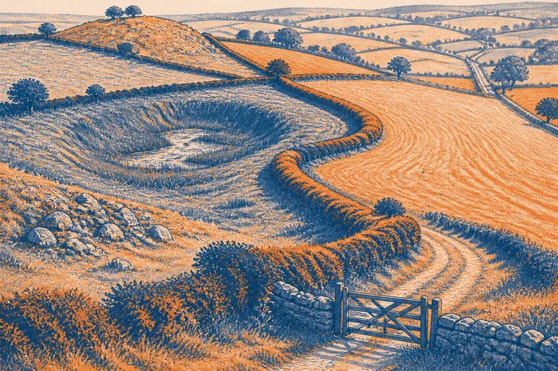
Why do old field boundaries bend? An old field boundary often turns where a plough met a stony ridge, where a hedge had to skirt a spring, or where one holding met a lane. The curve is not a failed straight line; it can be the trace of practical choices made across different kinds of ground.
Edges shaped by terrain
On a hillside, a boundary may follow a gentler shelf rather than cut directly up or down the slope. At a knoll it can swing around the higher ground; beside a hollow, it may keep to the drier rim. On a map, these adjustments often appear as broad arcs, sharp corners or a string of small kinks.
Stone, wet soil and springs can steer an edge too. A hedge might skirt rock that was awkward to clear, while a ditch marks ground that needs draining. Look for changes in surface, vegetation or slope near a bend, but do not treat any one sign as a complete explanation: later cultivation may have altered what is visible.
Work written into the line
A field edge is often a working arrangement, not simply a division on paper. A hedge can shelter crops and contain livestock; a bank may keep a boundary above wet ground; a ditch can carry runoff. One section might serve several purposes, and those purposes can change along its length.
Repairs and adjustments add further turns. A gateway may widen, a fence may be reset around a difficult patch, or a drain may run beside an older hedge. The present edge can therefore combine natural obstacles, deliberate divisions and later maintenance without revealing which came first.
Comparing boundary lines
Notice how the edge meets other features. Does it follow a stream, cross a contour, join a lane or align with neighbouring fields? A map can show these relationships, while a view from a public route may reveal a bank, ditch or hedge that helps explain them. Compare maps at different scales if available: a broad map may smooth out small turns that a detailed one preserves.
Say you are looking at a hillside map where a field edge curves around a hollow before running straight to a lane. You note that the hollow is visibly damp from the public path, and that the straight section meets the lane at a gateway. Taken together, those observations suggest that drainage may have shaped one section and access the other; they do not identify who made the line or when.
Keep the record concrete: mark where the edge turns, what lies beside it and which features it connects. If ownership or access rights are at issue, consult the relevant records or a qualified local professional; a map-reading impression cannot settle them.
What can a curved edge tell you?
Does a curved boundary mean the field is older?
No. A curve can survive later repairs, while an old division can be straight. Shape alone cannot establish a date.
Why might a hedge follow a contour?
It may follow a gentler strip of ground or mark a change in how the slope is used. Check the terrain alongside the line rather than relying on its shape alone.
Could a ditch explain a crooked edge?
It could, particularly where the boundary skirts a wet hollow or follows a route for runoff. But a ditch may have been added beside an existing edge, so it cannot explain every turn by itself.
What should you note on a map walk?
Record each clear turn, nearby slopes or hollows, and any meeting point with a stream, track, gateway or bank. Describe what you can see before proposing why it is there.
Clues and next decisions
- Observe whether the boundary follows a contour; if it does, compare the ground on either side, then describe the slope relationship rather than assigning a date. If it does not, check for another visible feature shaping the line.
- Observe whether a hollow beside the edge is wet; if it is, note that drainage may have influenced the boundary, then look for a ditch or outlet. If it is dry, avoid treating dampness as the explanation.
- Observe whether exposed stone sits close to a bend; if it does, consider whether the line skirts difficult ground, then check whether the hedge or bank actually follows it. If not, look for another nearby feature.
- Observe whether a ditch runs along the boundary; if it does, note its direction and where it meets a stream, then consider water management as one possible role. If it does not, do not infer drainage from the curve alone.
- Observe whether the edge joins a lane at a gateway; if it does, record that connection as a possible access influence. If there is no route or gateway nearby, do not use access to explain that section.
- Observe whether a bank, hedge and ditch continue together or change partway along; if they change, describe the sections separately. If they remain consistent, treat that continuity as a clue, not proof of a single origin.
Limits of the line
It is not worth inventing a single grand story for every kink. A small jog might reflect a repair, a mapping convention or a feature too subtle to recognise from a path. Spend attention instead on repeated alignments between boundaries and visible terrain, while keeping uncertainty in the description.
Why old field boundaries bend is best answered one section at a time. A curve becomes informative when it connects to a contour, hollow, bank or access route; without that context, it is simply a curve. Read the line alongside those features, and you can describe what the landscape suggests without claiming more than it shows.