Reading Hills Through Contour Lines
Learn to read contour lines on a topographic map, distinguish ridges, valleys and saddles, and sketch how the land fits together.
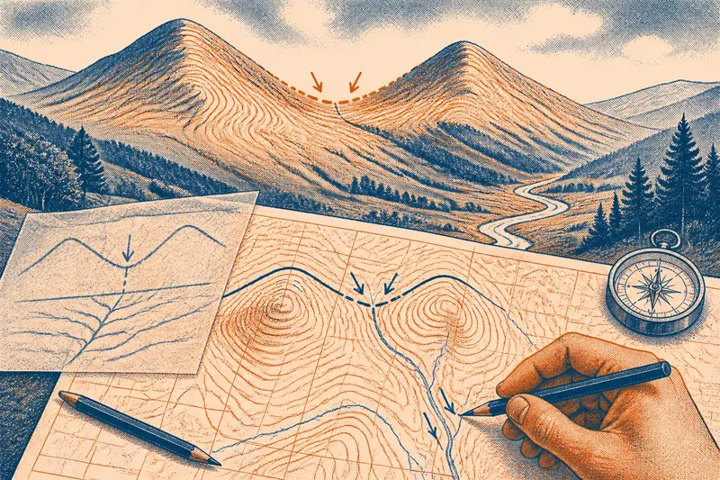
Where does a ridge end and a valley begin? Contour lines on a topographic map can answer that question, and help you see how a saddle links two slopes. Start with the shape of the whole landscape, then follow the lines that reveal its ridges, hollows and divides.
Choose a map with a connected group of hills and a valley floor. Before interpreting it, check the legend, north arrow or grid, scale and contour interval. Contours show elevation and landform; streams, roads and spot heights add different kinds of information. Keep a pencil and tracing paper handy for a sketch, but leave the original map untouched.
Read the high ground
Look first for clusters of closed contours. Where are the highest loops? Do they mark one rounded hill, several separate tops or a long crest? Follow the outer edge of the high ground and watch for places where it narrows, branches or sinks towards lower terrain.
Contour spacing offers a useful clue to slope. Closely packed lines indicate a steeper rise or descent; wider gaps suggest gentler ground. Read several lines together rather than judging one gap in isolation. A steep western flank and a more gradual eastern shoulder, for instance, may give a hill an uneven profile.
To pick out a ridge, imagine a line following the crest. The ground should fall away on both sides. A spur is a projecting branch of higher ground that descends from a larger crest, so it loses height along its length. Sketch only the main ridge and its larger spurs; a simple framework is easier to compare with the valleys than a tracing of every contour.
Trace valleys and streams
Where contours cross a mapped stream, their V shapes generally point upstream, towards higher ground. The water flows downhill in the opposite direction. Similar V shapes without a stream can suggest a hollow, but the contour pattern alone does not confirm that a watercourse is mapped or present.
Follow a valley from its head towards lower ground. Note whether it begins as a shallow notch or cuts deeply into the hills, and whether smaller hollows feed into it. A broad valley floor may show more widely spaced contours along the bottom; a narrow cut may have contours crowded close to the stream line. The map describes terrain shape, not every detail of vegetation, rock or water on the ground.
Now trace each valley’s sides back up towards the ridges. That connection matters: high ground divides drainage, while low ground gathers it. A quick sketch of the crest and its adjoining hollows can make the whole relief easier to understand than a list of isolated features.
Spot the saddle
A saddle is a low point along a ridge, with higher ground rising on either side of the divide. On a map, look for contours pinching inward between two higher areas before widening as they descend. A saddle may also be called a col, though names and local usage vary.
A valley head is different. It lies in a drainage hollow, where slopes generally rise away from the low line. Compare the neighbouring contours: does the feature sit between higher points on a crest, or at the end of a hollow? That distinction helps separate a pass from a valley even when both look like notches.
Contour spacing on a saddle’s approaches suggests whether the slopes are steep or gentle, but it cannot settle every question about access or ground conditions. For a real journey, check current mapping and local guidance rather than treating a landform reading as a safety assessment.
Questions about contour lines?
How do contour lines show a ridge?
Contours encircle high ground, with elevation rising towards a summit or crest. A ridge appears as connected high ground with lower terrain falling away on both sides.
Which way does a stream flow?
Where a stream is mapped, contour V shapes generally point upstream. Water flows downhill in the opposite direction, towards lower ground.
How is a saddle different from a valley?
A saddle is a low point on a ridge between higher ground along the divide. A valley is a lower channel or hollow, with slopes rising on either side.
Can contour lines tell me if a pass is easy to cross?
They suggest the shape and steepness of the approaches, but do not establish access or all ground conditions. For a planned journey, use current maps and relevant local advice.
Make a working sketch
Say you have an invented map with two adjacent summits, a narrow saddle between them and a stream valley curving away from the eastern slope. You mark the crest, then follow the stream’s contour V shapes upstream; next, you compare the saddle with the hollow to check which lies on the divide. The resulting sketch shows a crest between the summits, a pass on that crest and drainage leading away into the valley. If the contours do not clearly support one connection, leave it uncertain rather than forcing the lines to fit.
Use plain notes such as “steep western flank”, “shallow hollow below the northern shoulder” or “saddle links two high areas”. If two readings seem plausible, note what map detail would help distinguish them, such as a clearer contour pattern or a mapped stream. It is not worth tracing every contour or calculating every point’s height; focus on the lines that reveal a change in landform.
Before setting the map aside, compare your sketch with the original. Check that ridges divide valleys rather than run through their bottoms, and that a saddle sits on a crest between higher ground. A clear reading of contour lines is most useful when it shows how small features belong to the larger terrain—and leaves room for uncertainty where the map does not settle the question.